Prayagraj District, formerly known as Allahabad, is one of the most historically significant and geographically diverse districts in Uttar Pradesh. The area of Prayagraj District plays a major role in its administration, population distribution, agriculture, education, and development planning. Understanding the total size of Prayagraj helps residents, students, researchers, and travelers understand how large the district is and how its land is divided between rural and urban regions.
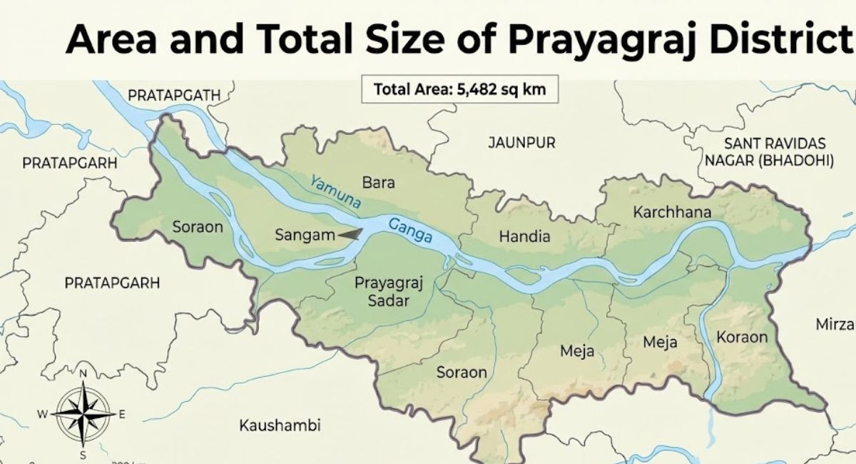
The total geographical area of Prayagraj District is 5,482 square kilometers, making it the 5th largest district in Uttar Pradesh by area. Most of this land is rural, with villages, farmland, forests, rivers, and natural landscapes spread across the region. Only a small part of the land is urban, including Prayagraj city and nearby towns.
In this article, you will learn the total area of Prayagraj District, rural and urban land distribution, administrative divisions, bordering districts, and why the district’s size matters for development and planning.
Total Area of Prayagraj District
The total geographical area of Prayagraj District is approximately 5,482 square kilometers, which equals about 2,117 square miles. This large land area places Prayagraj among the biggest districts in Uttar Pradesh in terms of size.
The area of Prayagraj District includes cities, towns, villages, agricultural land, rivers, forests, and open land. Because of its large area, Prayagraj supports a massive population and diverse economic activities such as farming, education, trade, tourism, and government services.
In Uttar Pradesh, Prayagraj ranks as the 5th largest district by total area, which shows its importance in the state’s administrative and geographical structure.
Rural and Urban Area Distribution in Prayagraj
The district of Prayagraj is mainly rural in nature. Most of the land is used for agriculture and villages, while cities and towns occupy a smaller part.
Rural Area of Prayagraj District
The rural area of Prayagraj District is approximately 5,279 square kilometers, which equals about 2,038 square miles. This accounts for nearly 96.3 percent of the total land area.
The rural regions include thousands of villages, agricultural fields, riverside settlements, and forested areas. Farming is the main occupation in these regions, with crops like wheat, rice, pulses, sugarcane, and vegetables grown widely.
Urban Area of Prayagraj District
The urban area of Prayagraj District is around 203 square kilometers, which equals about 78 square miles. This forms only 3.7 percent of the total district area.
Urban land includes Prayagraj city, townships, industrial zones, educational institutions, and infrastructure such as roads, railways, and government offices. Even though the urban area is small in size, it is densely populated and serves as the administrative and educational hub of the district.
Administrative Divisions Based on Area
Due to its large geographical size, Prayagraj District is divided into several administrative units for governance and development.
Tehsils of Prayagraj District
Prayagraj District is divided into 8 Tehsils, each responsible for local administration, land records, and revenue collection.
The tehsils are:
- Prayagraj Sadar
- Soraon
- Phulpur
- Handia
- Karchhana
- Bara
- Meja
- Koraon
Each tehsil covers a large land area with multiple villages and towns. These divisions help the government manage land, agriculture, infrastructure, and public services efficiently.
Bordering Districts and Geographic Location
Prayagraj District is located in the southeastern part of Uttar Pradesh and has a strategic geographical position. Its large area allows it to share borders with multiple districts and one state.
Districts Bordering Prayagraj
Prayagraj District shares its boundaries with:
- Pratapgarh
- Jaunpur
- Sant Ravidas Nagar (Bhadohi)
- Mirzapur
- Kaushambi
- Chitrakoot
It also shares a border with Rewa District in Madhya Pradesh, which makes it an important gateway between Uttar Pradesh and central India.
Importance of Prayagraj District’s Large Area
The large area of Prayagraj District affects many aspects of life and development.
Agriculture and Land Use
Because most of the land is rural, agriculture plays a major role in the district’s economy. Farmers depend on fertile land along the Ganga, Yamuna, and other rivers. The large land area supports food production for millions of people.
Population Distribution
A large district area helps spread the population across villages and towns. However, urban areas remain crowded because many people move to the city for education and jobs.
Infrastructure Development
The size of Prayagraj District makes infrastructure planning challenging. Roads, schools, hospitals, and electricity must reach remote villages spread across thousands of square kilometers. The government plans development projects based on the total area and population density.
Education and Institutions
Prayagraj is famous for Allahabad University and many colleges and schools. The large district area allows the establishment of campuses, research centers, and residential zones.
Tourism and Culture
Prayagraj hosts the Kumbh Mela and Magh Mela, which require large open land areas along the rivers. The district’s large geographical size helps manage such massive events.
Comparison with Other Districts in Uttar Pradesh
Prayagraj being the 5th largest district in Uttar Pradesh shows its importance. Many districts in UP are smaller in land area, which limits agricultural expansion and infrastructure planning.
Large districts like Prayagraj, Lakhimpur Kheri, Sonbhadra, and Bahraich have vast rural regions and natural resources. Prayagraj stands out because it combines a large rural area with a major urban center.
Key Geographic Features Within the District
The total area of Prayagraj includes several natural and geographical features.
Rivers
- Ganga
- Yamuna
- Tons
- Smaller tributaries and canals
These rivers make the land fertile and support agriculture and daily life.
Plains and Forest Areas
Most of Prayagraj lies in the Indo-Gangetic plains, which are ideal for farming. Some parts, especially in Meja and Koraon, have hilly and forested terrain.
Urban Centers
Prayagraj city is the main urban center, along with smaller towns in different tehsils. These towns serve as markets and administrative hubs for surrounding villages.
How Area Impacts Governance and Planning
The large area of Prayagraj District requires effective governance. Authorities divide the land into tehsils, blocks, and villages to manage services.
Land records, property registration, agricultural schemes, and disaster management depend on accurate area measurements. During floods or droughts, officials plan relief operations based on land distribution and population spread.
Frequently Asked Questions About Area of Prayagraj District
What is the total area of Prayagraj District
The total geographical area of Prayagraj District is about 5,482 square kilometers.
How much of Prayagraj District is rural
Around 96.3 percent of the district area is rural, which equals about 5,279 square kilometers.
How much of Prayagraj District is urban
Urban areas cover about 203 square kilometers, which is around 3.7 percent of the total area.
How many tehsils are in Prayagraj District
Prayagraj District has 8 tehsils including Prayagraj Sadar, Soraon, Phulpur, Handia, Karchhana, Bara, Meja, and Koraon.
Which districts border Prayagraj
Prayagraj shares borders with Pratapgarh, Jaunpur, Bhadohi, Mirzapur, Kaushambi, Chitrakoot, and Rewa district of Madhya Pradesh.
Conclusion
The area and total size of Prayagraj District make it one of the largest and most important districts in Uttar Pradesh. With a total area of 5,482 square kilometers, the district is mainly rural, with fertile farmland, rivers, and thousands of villages. The urban area is small in size but densely populated and economically significant.
Understanding the geographical size of Prayagraj helps in education, governance, tourism planning, and development projects. Whether you are a resident, student, researcher, or traveler, knowing the total area of Prayagraj District gives a clear picture of its scale, diversity, and importance in India.

Maharshi Kushwaha is the founder of Prayagraj Portal, a digital platform dedicated to providing accurate news, city updates, culture, education, tourism, jobs, events, and essential services related to Prayagraj (Allahabad). Though he is not originally from Prayagraj, he frequently visits the city and works closely with a strong local team to ensure authentic and responsible reporting. A passionate digital creator and youth entrepreneur, he focuses on building meaningful platforms that promote information access, youth engagement, and community development. His vision is to make Prayagraj Portal one of the most trusted and impactful digital sources for everything related to Prayagraj.